Sunday 7 September 2014

Day 14 to 16: Ottawa and then to Waterloo

Ottawa back Home

We're home now!  According to the odometer on the truck, we drover about 7,500 km over 16 day.  Our last 2 days were in Ottawa, celebrating our 5 year anniversary.

Thanks for following our blog, and hopefully this inspires someone else to take a trip to Labrador & NFLD.

But before I finish, an interesting bit of history that I missed.  On the drive from Baie Comeau, Quebec to Labrador City, we passed through a weird looking stretch of road.
The highway randomly split into a boulevard, with sidewalks and sections of road with driveways extending from the highway.
This lasted for about 5min of driving, but all around was just bush and no visible sign of any buildings.
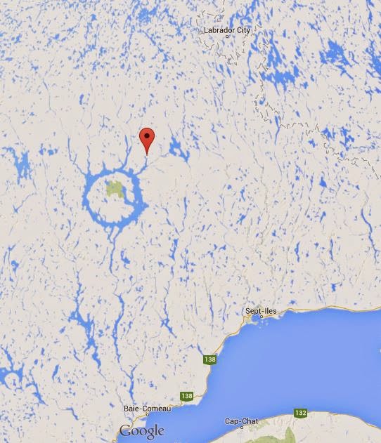
Town of Gagnon
The highway was actually build through the ghost town of Gagnon, Quebec.
It was another company town opened by a mining corporation in the 1960s.  There was no road access and the only way of getting there was by plane.  At its peak, there was a population of 4000 people, but due to a decline in Iron Ore, the mine closed shop, and the town was completely disassembled in 1985.

The part we drove through was the main boulevard of the town.  It was probably one of the most random things to see sidewalks and a boulevard to randomly appear while driving on a gravel road.
There were no signs explaining the history or what this was when we drove through it,

the boulevard and sidewalks

Gagnon from 1962


Thursday 4 September 2014

Day 13: The Long drive back to Quebec

Day 13: Moncton NB to Trois Rivieres QC

I'm very sad to say that today was our last day in the east coast.  Today we drove from Moncton, New Brunswick to Trois Rivieres, Quebec.  It was a very very long drive, taking about 9 hours total on the Trans Canada.


There's no direct route through Maine, so the Trans-Canada has to go north, and then turn south west along the south shore of the St Lawence River. The drive through New Brunswick was very boring.  The hwy was just straight for most sections, and nothing to see but trees and the occasional lake or river.  At least the speed limit was 110 kph.

As we drove into Quebec, there was a town called Saint-Louis-Du Ha! Ha!
Those exclamation marks are actually part of the name of the town...so awesome
According to wiki, its the only town name in the world with 2 exclamation marks.

We arrived in Trois-Rivieres by 5pm. Marg's Fit-Bit strap broke (watch type thing that measures how active she is), so we made a beautiful walk through Trois Rivieres' slightly sketchy side to get some Hello Kitty tape  at a Wall Mart to fix her strap. Tomorrow is off to Ottawa for 2 days.
Ottawa should be fun, but we are sad that our time in the east coast is done...bye bye NFLD

Wednesday 3 September 2014

Day 12: Off to New Brunswick

Day 12: Sydney, NS to Moncton, New Brunswick

It sure is foggy on the east coast.  We woke up on Day 12 to more fog and light rain.  As a last minute change, we decided to visit the Fortress of Louisbourg before heading off to Moncton.

The Fortress of Louisbourg is another Canadian Historic site.  The original settlement started in 1713, and became a major commercial fishing hub, and fortress by the French.  The original buildings/fort were all destroyed but rebuilt in the 1960's to accurately replicate what it would have looked like.

I love this kind of stuff...it's a living museum so we can tour the buildings, see how people lived, and buy bread made in the original bakery.


We finished the tour around 12:00, and then made the 5 hour trip to Moncton.
In Moncton I had my first lobster dinner with 1 lbs of muscles at a restaurant called Catch 22.
The picture speaks for itself !


Tuesday 2 September 2014

Day 11: Cabot Trail

Day 11: Cabot Trail Hike

Our ferry from NFLD arrived in New Sydney, NS at 9:00 am Atlantic Time (yes another time change).  It was so nice to sleep and wake up well rested for the next day...so much nicer than sitting in a seat for 16 hours.

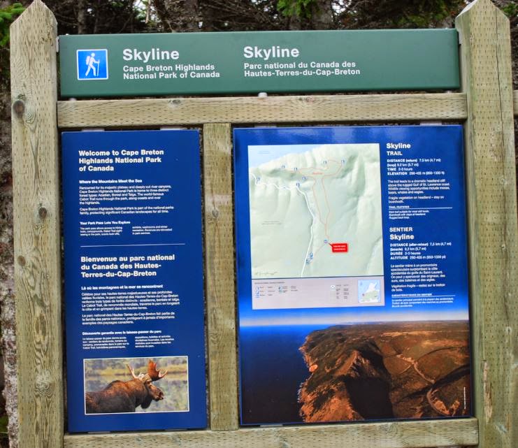
Skyline Trail


After disembarking, we drove to Cape Breton Highlands National Park via the Cabot Trail and choose the skyline trail for a short 10K hike. The hike was a bit too much of a stroll rather than a hike for our tastes, but the view was amazing. On our way back we had some delicious icecream at Mr Chicken which was the perfect end to our hike.


Beach at Cabot Trail


Day 10: St John's to North Sydney, NS

Day 10: Tour of St John's and then Ferry to Nova Scotia

Since there wasn't any internet connection on the Ferry, I'm updating for the last 2 days.

Day 10 started off in St John's with a tour of Signal Hill (Cabot tower) and then Cape Spear and the lighthouse there.  Unfortunately we didn't end up having enough time to go to Dildo, but instead headed off to Argentia to catch the 16 hour ferry ride to Nova Scotia.


We woke up early and were at Signal Hill before it opened...yes we are keeners.   The good thing was that we had the whole of Signal Hill mostly to our selves.  On the summit of Signal Hill is the Cabot Tower, which was constructed in 1898 to commemorate the 400th anniversary of John Cabot's voyage to the new world.
It was very foggy at first, but it lifted and we could see wonderful views of the harbour and St John's.
Signal Hill is also the location of the first trans-Atlantic wireless signal.  Marconi setup wireless radio transmitters on Signal Hill, and received the first signal from England.

St John's Harbour from Signal Hill

Cabot Tower on Signal Hill
We still had a couple hours before leaving or the ferry, so we headed to Cape Spear, which was about a 20min drive from St John's.  Cape Spear is a National Historic Site, and has one of Canada's oldest light houses.  But more interestingly, it is the most eastern part of Canada and still has remnants of WW2 artillery pill boxes.  The massive guns and underground tunnels from 1943 are all still there...pretty cool.

The most eastern part of Canada at Cape Spear

WW2 artillery pill boxes at Cape |Spear

We headed to Argentia, NL to catch the Ferry that took us to North Sydney, NS.  It's a 16 hr trip, but we splurged and booked a deluxe cabin with a nice bed and shower!  It was so worth the extra cost since I couldn't image sitting in reclining seats for that much time.


Sunday 31 August 2014

Day 9: Off to St John's

Day 9: Norris Point to St John's

Yes, there is an apostrophe in St John's....I've always gotten St. John's mixed up with Saint John in New Brunswick.

We woke up in Norris Point (near Gros Morne) to pouring rain, but we were happy that the rain had held off until we finished climbing Gros Morne mountain.  Our drive to St John's was long, but the highway is well paved, and pretty easy compared to the earlier roads we've been driving on.

We passed through Gander, and arrived in the capital of NFLD around 5pm.
Our hotel is at the historic Murray Premise , which used to be a shipping warehouse back when Cod fishing was the main industry in NFLD.

St John's is picturesque with brightly painted row houses, and a nice downtown near the waterfront.
Tomorrow we tour signal hill, and then board the 16hr ferry back to Nova Scotia
View of harbour in St John's
Murray Premesis - our hotel
Water street - St John's
Row Houses - painted colourfully
Newfoundlander dog - it is 1.5 actual size


Signal hill - see the Cabot tower on top of the hill

Saturday 30 August 2014

Day 8: Gros Morne Mountain


Day 8: Let's climb a Mountain

Today we stayed in Gros Morne National Park, so we didn't have to drive anywhere...yay
Gros Morne Mountain is the highest point in the national park at 800m, and takes about 4-8 hours to climb.

We arrived at the parking lot at the trail head by 10am, and started hiking up the first 4km uphill trail, while passing streams, and lakes.  This led us to the base of the mountain and the more strenuous hike began.

Gros Morne Mountain from the approach


The first 3/4 of the trail is located in a valley of the mountain and is mostly large, sharp rocks.  It takes some delicate foot placement to prevent rolled ankles.  Marg lead the way and she kept a good pace all the way to the top.  The wind started to pick up as we climbed higher and we had to put on our jackets once we reached the top of the boulder field.
At the base of the mountain


About 1/2 way up 

Lots of rocks

The trail actually flattened out and changed a smoother terrain for the last 1/4 of the way to the summit.  The views were fantastic, and totally worth the effort to get to the summit.
The route down...board walks along sensitive areas

Small shelter at the summit blocks the strong wind

Summit !

The best view
The route down was around the back side, and much less steep terrain.  We both preferred the uphill section as the downhill was hard on the knees.
We reached the parking lot by 3:30, so it took us around 5.5 hours to finish the climb.  

Tomorrow we're off to St John's !